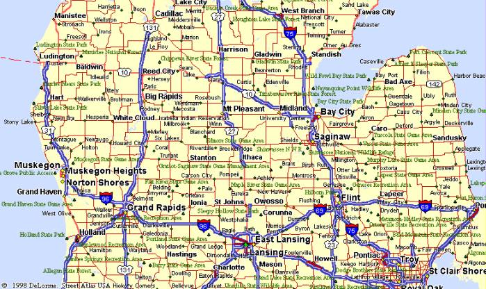
Alternate Routes from Detroit to Forager’s Forest listed in order of preference.
I-75 North through Flint (I-75/U.S. 23) and Bay City, U.S. 10 West through Clare and Reed City to Idlewild.
I-96 West to Brighton, U.S. 23 North through Flint (I-75/U.S. 23) and Bay City, U.S. 10 West through Clare and Reed City to Idlewild.
I-96 West to East Lansing, U.S. 127 North, to U.S. 27 North through Mt. Pleasant to Clare, U.S. 10 West through Reed City to Idlewild.
I-96 West through Lansing to Grand Rapids, U.S. 131 North through Big Rapids to Reed City, U.S. 10 West to Idlewild.
I-96 West through Lansing and Grand Rapids, M-37 North through Newago and White Cloud to Baldwin.
From Idlewild-
At Idlewild flasher, stay on U.S. 10 West 1 mile to Forman Rd.
Go South (left) on Forman Rd. 1 mile to Baldwin Rd., West (right) on Baldwin Rd. 1 mile to Indianapolis Ave.
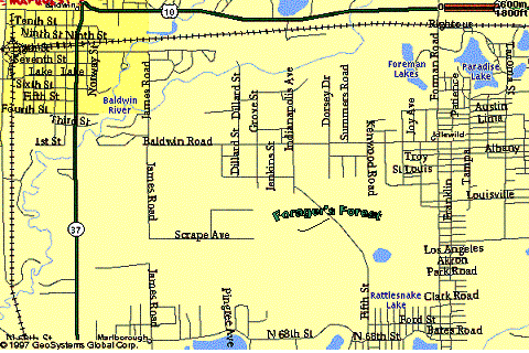
From Baldwin-
On M-37 North in Baldwin, just past Jone’s Ice Cream, turn East (right) on Eighth Street.
Take Eighth Street out of town and it turns South (right) to become James Road.
Follow paved road ˝ mile as it turns East (left) and becomes Baldwin Rd.
Go 1 mile east on Baldwin Rd. to Indianapolis Ave.
Turn South (left) on Indianapolis 1/3 mile to trail road (watch for post marked FF on left), Left 1/3 mile to Right onto trail road to Camp.